
Maritime & Offshore
Maritime & Offshore
Over-Water Exploratory Drilling, Marine Subsurface Stratification, and Coastal Foundation Telemetry for Port & Marine Structures
Category Overview Narrative
Marine and nearshore civil engineering presents extreme geotechnical challenges. Designing stable deep-water berths, port terminals, breakwaters, jetties, and coastal elevated expressways requires understanding unpredictable seabed dynamics, highly compressible marine muds, variable loose sands, and bedrock socketing conditions under dynamic wave and tidal forces.
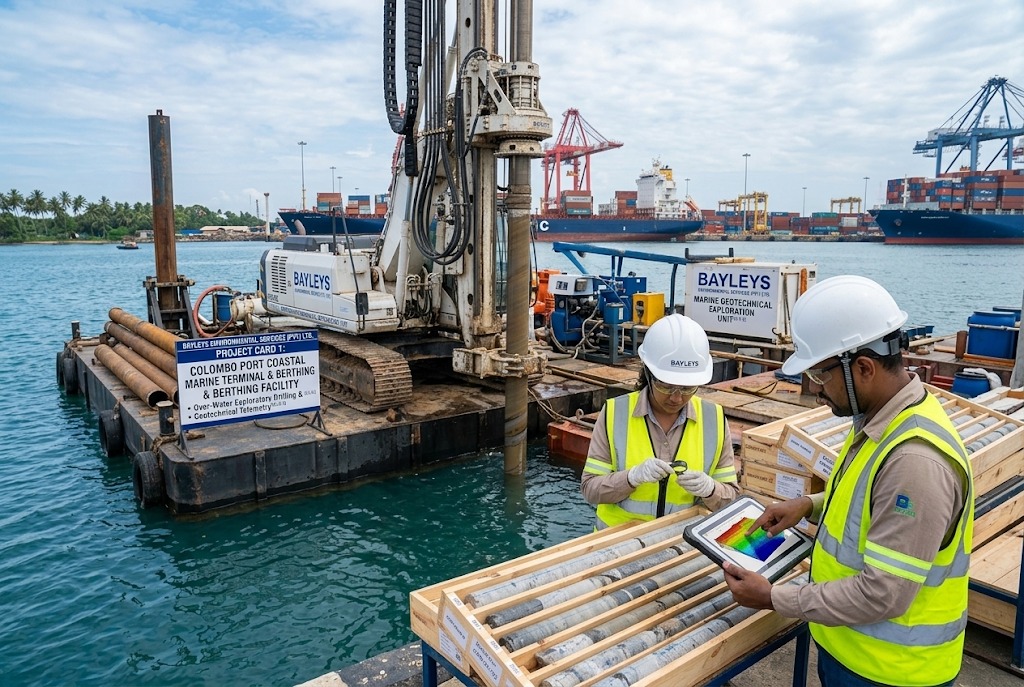
Bayleys Environmental Services (Pvt) Ltd. provides specialized marine and offshore geotechnical investigation capabilities across coastal and inland water bodies. Utilizing specialized barge-mounted drilling platforms, heavy-duty casing systems, and polymer-balanced drilling fluids, our teams deliver pristine core recovery and in-situ metrology in the most challenging marine environments.
- Project Card 1: Coastal Marine Corridor & Port Access Geotechnical Exploration
Card 1 Title: Port Marine Corridor & Elevated Transport Section – Coastal Borehole Investigations
Client: Foundation and Waterwell Engineering (Pvt) Ltd.
Location: Colombo Port Coastal & Intertidal Zone, Sri Lanka
Card 1 Summary Excerpt: Specialized marine and coastal geotechnical campaign executing high-depth exploratory boreholes across soft marine sediments, tidal intertidal zones, and bedrock interfaces for heavy marine transport piers.
Card 1 Button: Read More →
Detailed Case Study Content (For 'Read More' Page View):
- Project Background & Objective: Geotechnical site investigation for major coastal infrastructure interfacing with port waters, requiring rigorous subsea soil profiling to mitigate marine foundation settlement and lateral cyclic wave loading.
- Geotechnical Scope of Work: Executed deep rotary core drilling through thick marine clay layers, loose littoral sands, and decomposed rock horizons into sound metamorphic basement rock. Performed in-situ Standard Penetration Tests (SPT) and undisturbed sampling under tidal groundwater conditions.
- Technical Challenges Overcome: High tidal variations, marine salinity, and borehole wall instability in saturated marine muds. Deployed specialized heavy marine casing and environmentally safe biodegradable drilling muds to maintain borehole integrity and achieve high Total Core Recovery (TCR).
- Engineering Outcome: Provided comprehensive subsea stratigraphy profiles, rock quality designations (RQD), and allowable end-bearing and skin friction parameters for deep marine pile socketing.
- Project Card 2: Nearshore Jetty & Breakwater Geotechnical Mapping
Card 2 Title: Nearshore Marine Berth & Breakwater Alignment – Subsurface Geotechnical Exploration
Client / Sector: Maritime Infrastructure & Port Development Sector
Location: Western Coastal Maritime Zone, Sri Lanka
Card 2 Summary Excerpt: Exploratory marine drilling and in-situ field testing to map seabed bearing capacity, sediment layer thicknesses, and rock bed stability for coastal marine structures.
Card 2 Button: Read More →
Detailed Case Study Content (For 'Read More' Page View):
- Project Background & Objective: Subsurface feasibility study for nearshore maritime facilities, requiring evaluation of seabed stability, scoured seabed zones, and wave-induced dynamic soil response.
- Geotechnical Scope of Work: Mobilized over-water drilling setups to execute exploratory boreholes across harbor and nearshore alignment points. Conducted field vane shear tests in soft cohesive seabed sediments and continuous SPT resistance logging.
- Laboratory & Chemical Testing: Evaluated seawater chloride and sulfate concentrations, organic matter contents, and triaxial shear parameters to verify foundation concrete durability in aggressive marine environments.
- Engineering Outcome: Delivered verified engineering parameters for gravity breakwater stability, marine sheet pile wall designs, and heavy berthing dolphin foundations.
- Right Sidebar Widget Content Configuration
Search Field Placeholder: Search projects, services, reports...
Categories Widget:
- Highways & Expressways (2)
- Multi-Storey Buildings (2)
- Maritime & Offshore (2)
Most Viewed Projects Widget (Titles & Thumbnails):
- Port Marine Corridor & Elevated Transport Section – Coastal Boreholes
- Nearshore Marine Berth & Breakwater Alignment – Subsurface Mapping
- Port Access Elevated Highway Project – 32 Deep Coastal Boreholes